Programme Overview
What is GEM?
The aim of GEM is to deliver top-class graduates from the EU and around the world, with the skills and networks to better manage socio-ecological systems for sustainable and equitable growth.
Management of the Earth’s resources requires easily accessed, up to date, and detailed data and the knowledge to acquire it, process it and generate actionable information from it.
New Earth observation data services, such as the European Union’s Copernicus Programme – provide access to the data. GEM provides the technical knowledge and professional skills to use it, communicate it, and act upon it.
Programme Structure
When you apply, you first choose one of the study tracks.
There are four tracks to choose from. These tracks integrate academic excellence from the four universities in geospatial science applied to societal challenges for a sustainable world. Each year is spent at a different university in a different European country, depending on the track you choose. See the Study Guide for details per track.
Study Guide
Download and review the official Study Guide for the GEM Programme in PDF format. The study guide provides a detailed overview of the programme structure and courses for all tracks and partner universities.
Partners and Associates
Partner universities
The Programme is a combined partnership of four different universities.
GEM integrates academic excellence from four leading universities and their respective MSc programmes in geospatial science in a strategic partnership to support innovative academic practices. Each partner addresses different aspects of human-environment interaction challenges with applied geospatial science:
- Natural resources management at University of Twente, Faculty of ITC, the Netherlands (ITC)
- Ecosystems and the environment at Lund University, Sweden (LU)
- Agriculture and forestry at UCLouvain University, Belgium (UCLouvain)
- Socio-ecological systems and urban planning at the University of Tartu, Estonia (UT)
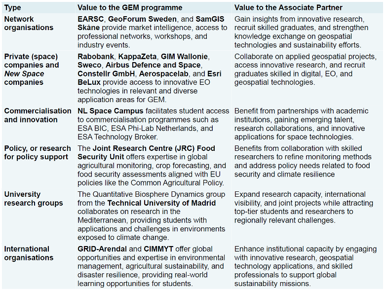
Associate partners
The GEM Programme has the support of many Associate Partners who, combined, provide a unique network of academic, industry, policy and non-governmental organisations with mandates to address social and environmental challenges.
The role of the Associate Partners is to:
- Take part in Joint activities such as (virtual) meetings, common teaching elements and hackathons – Provide possibilities for internships or fieldwork
- Provide help with MSc thesis research activities by developing research ideas (with real-life challenges)
- Provide input for the Partner Universities on educational material and help develop the curriculum with their expertise.
- Develop joint projects that contribute to the internationalization strategies of the different universities.