Programme Overview


What is GEM?
The aim of GEM is to deliver top-class graduates from the EU and around the world, with the skills and networks to better manage socio-ecological systems for sustainable and equitable growth.

Management of the Earth’s resources requires easily accessed, up to date, and detailed data and the knowledge to acquire it, process it and generate actionable information from it.

New Earth observation data services, such as the European Union’s Copernicus Programme – provide access to the data. GEM provides the technical knowledge and professional skills to use it, communicate it, and act upon it.

Each partner brings expertise in different aspects of human-environment interaction challenges with applied geospatial science:

A double degree in just two years

Graduates of the Erasmus+ Master of Science Degree (MSc) Geo-Information Science and Earth Observation for Environmental Modelling and Management (GEM) Programme will be awarded a double degree (in English).

Why choose GEM?

GEM is an innovative, international education programme from four European university partners that:

Download the brochure to learn more!

Would you like to discover everything about GEM? Want to be kept up to date on our news and activities?

Click the button on the right and receive the digital brochure with all you need to know about GEM.
Receive brochure


Programme Structure

When you apply, you first choose one of the study tracks.

There are four tracks to choose from. These tracks integrate academic excellence from the four universities in geospatial science applied to societal challenges for a sustainable world. Each year is spent at a different university in a different European country, depending on the track you choose. See the Study Guide for details per track.

Track 1: Geospatial Planner

🇪🇪 University of Tartu, Estonia & 🇳🇱 University of Twente, Faculty of ITC, the Netherlands

ℹ️ This track focuses on using geospatial technologies to support urban and environmental planning.

📚 In the first year, students build foundational skills in spatial data analysis, EO, and 3D modelling, complemented by electives in spatial databases, GeoPython, and planning studios. Internships provide practical experience with government, industry, or NGOs. In the second year, students specialise in digital participatory planning, environmental assessment, and ecosystem service analysis.

💼 This track is ideal for students with a background in Urban Planning, Geography, Environmental Science, or Civil Engineering, preparing them for roles such as Urban Planner, GIS Consultant, or Environmental Policy Advisor.

Track 2: Geospatial Analyst

🇪🇪 University of Tartu, Estonia & 🇧🇪 UC Louvain, Belgium

ℹ️ This track trains students to use geospatial data for environmental monitoring and spatial planning.

📚 Year 1 covers spatial analysis, EO, and geovisualisation, with elective courses and industry internships. In the second year, students focus on spatial modelling, landscape ecology, and land monitoring.

💼 Applicants with degrees in Geography, Environmental Science, Data Science, or Computer Science are well-suited for this track. Graduates often become GIS Analysts, Spatial Data Scientists, or EO Specialists.

Track 3: Geospatial Developer

🇸🇪 Lund University, Sweden & 🇳🇱 University of Twente, Faculty of ITC, the Netherlands

ℹ️ Designed for those aiming to develop custom geospatial solutions, this track combines programming, geospatial AI, and EO.

📚 Year 1 offers a strong foundation in geospatial data analysis and satellite data processing, while year 2 deepens expertise in quantitative remote sensing and AI-driven geospatial solutions.

💼 Ideal applicants have degrees in Computer Science, Geoinformatics, Engineering, or related fields. Career paths include GIS Developer, Spatial Software Engineer, and AI-Powered Geospatial Engineer.

Track 4: Geospatial Modeller

🇸🇪 Lund University, Sweden & 🇧🇪 UC Louvain, Belgium

ℹ️ This track emphasises spatial modelling and simulations to address complex environmental challenges.

📚 In the first year, students focus on GIS programming, geospatial AI, and EO. The second year involves advanced Earth system monitoring, spatial dynamics, and bioscience modelling.

💼 Applicants with backgrounds in Environmental Science, Geoinformatics, EO, or Ecology are suited for this track. Career paths include Environmental Modellers, Climate Data Scientists, and EO Specialists.

Check out the video made by Lund partners on the GEM course: here


Study Guide

Download and review the official Study Guide for the GEM Programme in PDF format. The study guide provides a detailed overview of the programme structure and courses for all tracks and partner universities.

Download the Study Guide

The Study Guide provides a detailed overview of the programme structure and courses for the September 2026 intake for all tracks and partner universities.

Click the button on the right and receive the Study Guide with all you need to know about GEM.
Receive study guide


Partners and Associates

Partner universities

The Programme is a combined partnership of four different universities.

GEM integrates academic excellence from four leading universities and their respective MSc programmes in geospatial science in a strategic partnership to support innovative academic practices. Each partner addresses different aspects of human-environment interaction challenges with applied geospatial science:


Associate partners

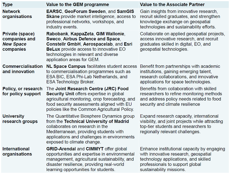
The GEM Programme has the support of many Associate Partners who, combined, provide a unique network of academic, industry, policy and non-governmental organisations with mandates to address social and environmental challenges.

The role of the Associate Partners is to:

Loading...